
Flood season has arrived in the Ottawa Valley and conservation officials are warning local residents to prepare for the springtime swelling of the national capital’s waterways.
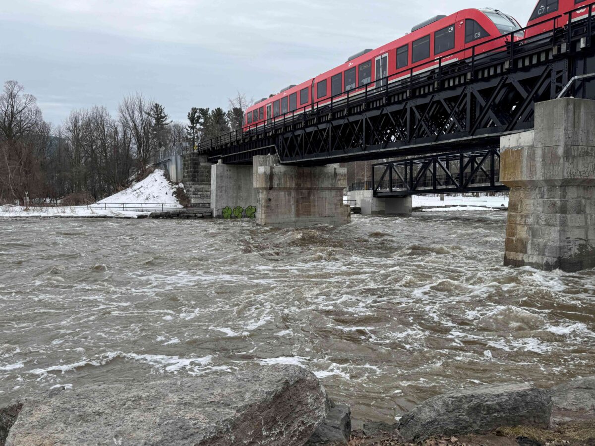
After record-breaking mild weather — including a high of 16.3 C on March 16, the highest temperature for that date in Ottawa — heavy snowmelt and rain are rushing over frozen ground and gushing into the Ottawa and the Rideau rivers.
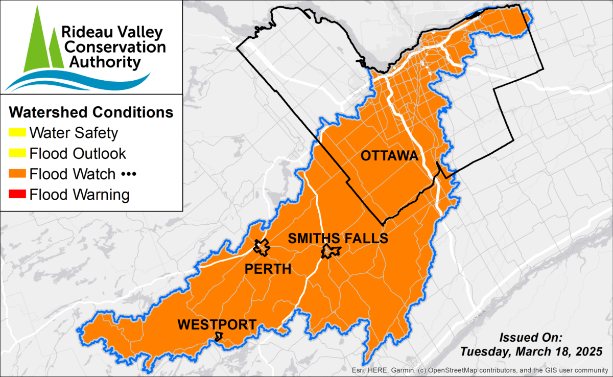
Flood watches are in place by the Rideau Valley Conservation Authority, which monitors the Rideau watershed that drains much of the city of Ottawa and ultimately flows into the Ottawa River at Rideau Falls.
On March 19, the RVCA issued a flood outlook for the Lower Ottawa River from Arnprior to Hawkesbury, including the Ottawa-Gatineau region.
“A large weather system brought 10 to 20 mm of precipitation over much of the Ottawa River basin between March 15 and 17. This system also brought warm temperatures that triggered a rapid melting of snow in the southern portion of the Ottawa River, marking the beginning of the spring freshet in the Ottawa River basin,” the RVCA stated.
“Rising levels along the main stem of the Ottawa River could create possible flooding in low-lying areas over the coming weeks. Low-lying areas are those that are regularly flooded during the spring freshet period,” the authority added. “While there are currently no flooding indicators of concern, it is still too early to forecast peak river conditions which remain dependent on snowmelt and rainfall amounts.”
A watch put in place by the RCVA on March 13 was localized to rural North Gower and was to last until March 18. Since then, the watch has been changed to encompass the entire Rideau Valley.
“Rising water levels and faster flows will continue to weaken ice cover throughout the week. Residents are advised to steer clear of shorelines as water levels may rise rapidly, and to stay off all ice.”
— Rideau Valley Conservation Authority, March 18
“The Flood Watch previously issued for parts of the Rideau Valley has been extended and expanded to include the entire watershed due to the risk of ice jamming as high temperatures and rising water levels continue to break up ice cover across the region,” the RVCA said on March 18. “Rising water levels and faster flows will continue to weaken ice cover throughout the week. Residents are advised to steer clear of shorelines as water levels may rise rapidly, and to stay off all ice.”
The Rideau flood watch is on until March 21, but a general water safety warning is in effect throughout the watershed until mid-April.
In addition to rain and snowmelt raising water levels, RCVA warns of ice jams that block a waterway, displacing the water out of the river onto surrounding areas.
The watersheds of the Rideau and Ottawa rivers encompass a vast area including all of Eastern Ontario and Western Quebec as the streams pass through urban and rural areas along their respective 147-kilometre and 1,271-km runs. Thousands of homes and dozens of communities lie along the shores of the rivers in flood-prone areas.
In the last decade, the river has seen two “century floods.” These events are named after the once-in-100-years or one-per-cent chance that a water course has of extreme swamping of its flood plain (see City of Ottawa interactive map). But with climate change, “century floods” are happening more regularly than once in century.
Ottawa’s first major flood in the last decade happened in 2017, when about 257 mm of precipitation combined with spring runoff to flood highways, homes and hectares of shoreline property between April 5 and May 13.
The second in 2019 was caused largely by a cold spell that held the snowpack until mid-spring, when heavy rainfall met with the suddenly unleashed snowmelt. More than 6,000 homes were flooded or put at risk in Ottawa-Gatineau and a state of emergency was declared for Ottawa from April 25 to June 12.
Larissa Holman, director of science and policy for the Ottawa Riverkeeper said the Ottawa River is an interesting flooding case study because of its great length and expansive watershed on both sides of the Ontario-Quebec border.
Holman said southern sections of the river will flood from warming temperatures while more northern sections can have different conditions and no flooding amid cooler temperatures.
Holman said weather throughout the river’s drainage basin have to be considered when monitoring the Ottawa for flood risks.
“You have to bring a watershed approach to these issues,” Holman said. “It can’t be done (for) one province or another, or one region or another. It needs to be done from a whole watershed approach.”
Holman said flooding should be expected most years — this spring included. But she said predicting the extent or timing isn’t easy because of the rate of thawing snow, intensity of rain and a host of other factors impact water levels.
While the unpredictable temperature and precipitation forecast leaves a lot of uncertainty for Ottawa residents, organizations such as Environment Canada, RCVA and Ottawa Riverkeeper work around the clock during the spring to stay on top of warning signs relay the implications to Ottawa residents living near the river.
Tyler Bauman, RCVA’s water management engineer for flood management, said the best protection is preparation.
Bauman said all homeowners with houses known to be at risk need to double-check safety measures, such as clearing out all potential blockages to sump-pumps, filling generators with fuel and ensuring they are operational while prepping sandbags for creating barriers against the water.
“Go through the steps ahead of time,” said Bauman, “so you’re not reacting during the event.”


